The Deep End – Lake Neusiedl: Development Denied (The Lost Lands #48)

There is always an exception to the rule. Imagine a communist government during the Iron Curtain era in Eastern Europe protecting natural resources. Examples of this are so few and far between that it is hard to believe. Communist governments had a well-deserved reputation for degrading the environment. Natural resources were to be exploited to industrialize supposedly backward societies at a breakneck pace. The environmental and human costs from the communist’s point of view were collateral damage. Destroying one world to build a reputedly better one was the idea. Eastern Europe went from underdeveloped to mis-developed. The result was grotesquely polluted cities, and altered ecosystems that would need decades to heal from the damage inflicted upon them. The communist governments were banking on Marxist theory. No wonder they ended up financially and morally bankrupt.

Despite a horrific record there were a few success stories. Predictably these did follow any five-year plans. Instead, they were the product of planned neglect. A prime example was the Bialowieza Forest on the border between Poland and the Belarusian Soviet Socialist Republic (present-day Belarus). The forest is home to the only stretch of primeval forest that once covered the European Plain. The Polish portion was protected within a National Park, while the Belarusian SSR’s was protected by state decrees. The forest was left undeveloped and in a state of nature. A similar situation occurred with the Hungarian part of Lake Neusiedl (Neusiedler See)/Ferto-to (Lake Ferto) on the Austria-Hungary border. 

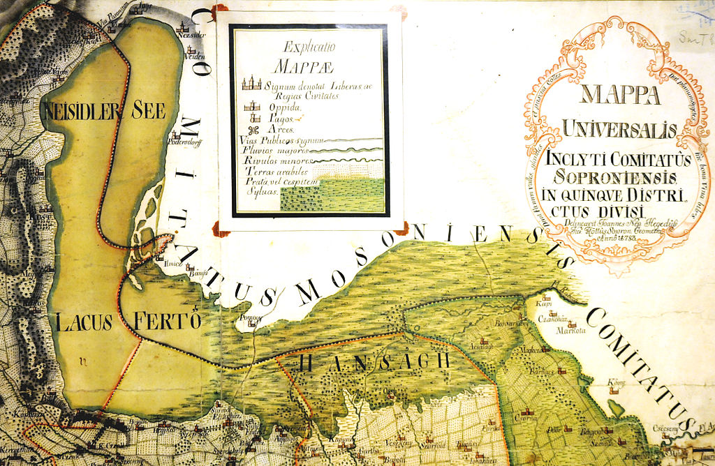
State of nature – Map of Lake Neusiedl-Ferto-to and the Hansag in 1783

Turbulent Waters – No Day At The Beach
It is not a coincidence that two of the best examples of communist governments in Eastern Europe protecting natural resources occurred in borderlands. The areas along their national borders were no man’s lands where travel was either restricted or banned. Borders were militarized and under constant surveillance. This was as true with borders between nations in the Eastern Bloc, as it was with those bordering western nations. Everyone was under suspicion, more so when they crossed a border. In communist societies, all resources, human and natural, were marshalled in support of ideological goals. The ends justified the means. Nature could be politicized just like the people. This happened with the Hungarian portion of the Neusiedler See. It was the only part of the Austria-Hungary border divided by a body of water. Furthermore, parts of the border were in the water. That would make it much more difficult for the communist authorities in Hungary to police.

Extending the Iron Curtain from land to water could be an expensive task. The government had to keep people out of the water and inside Hungary. The only way to do this was by closing off all activity on Hungary’s part of the lake. Hungarians would not be birding in reed beds, windsurfing or frolicking in the shallow waters. There were not going to be any days at the beach. Taking a dip could get someone arrested or killed. The upshot of banning access for Hungarians to Lake Neusiedl was that a quarter of the lake would be left in its natural state. Being on the border saved the lake from a potentially worse fate. If it had not been on the border, Hungary’s communist government might have tried to alter the lake for agricultural or industrial usage. They would not have been the first Hungarian government with such ideas. For a long time, it was thought that nature could be bent to the human will. Hard lessons would be learned.

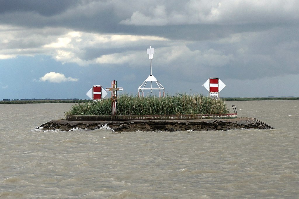
Watermark – Landmark with cross at the Austria-Hungary border during the Cold War
(Credit: Naturpuur)

Fluctuating Potential = A Drain On Resources
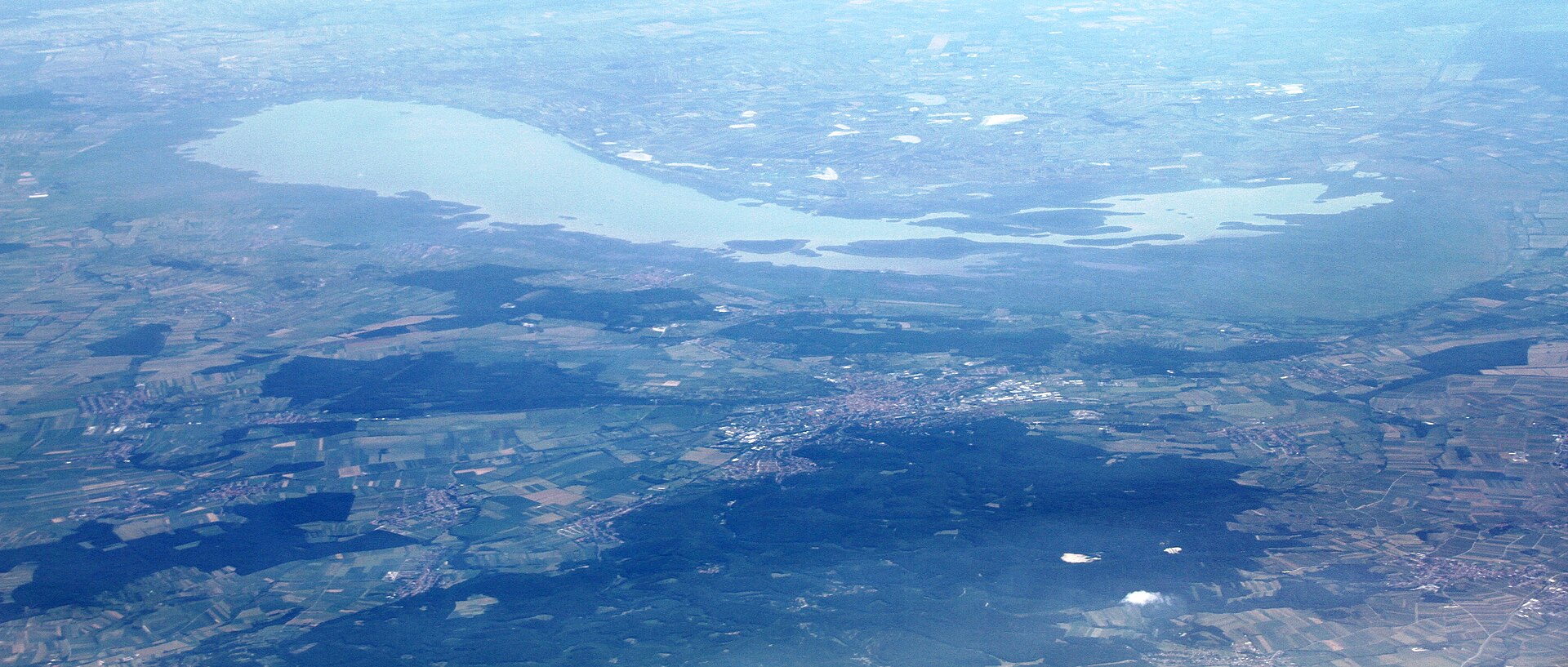
Lake Neusiedl was completely within the territory administered by the Hungarian half (Transleithania) of the Austro-Hungarian Empire prior to the Treaties of St. Germain-en-Laye and Trianon assigned 75% of the lake to Austria. While under Hungarian administration there were plans afoot to utilize the lake for agriculture. This seems rather bizarre considering that Hungary has some of the most fertile land found anywhere in Europe. The push for development in Hungary during the 19th and early 20th centuries had tamed the Danube and Tisza Rivers with flood control measures. Draining water-soaked land for farming was nothing new. Lake Neusiedl was an inviting target. The water’s average depth is 1.5 feet (46 cm), and at no point is the water deeper than 5 feet 11 inches (180 cm).

Mother nature had done the lake no favors when it dried up completely in 1866. Those with agricultural designs could see the land beneath the lake and wonder what might be done. Ten years later though, the lake was full again. That offered another idea. The water could be diverted for agriculture and the reclaimed land cultivated. Never mind that the wild fluctuations in the lake’s level were natural. Since its formation sometime between 18000 and 14000 BC, Lake Neusiedl has dried up every hundred years on average. The lake was too good of an opportunity for those with visions of development to ignore it. They could point to the Hansag, an area of swamp and marshland not far from Lake Neusiedl. A large part of it had been drained over the past few centuries.

Watching the sunset – Lake Neusiedl at Podersdorf

Transformative Nature – Protection & Preservation
A plan was formulated in the early 20th century to harness the Lake Neusiedl’s potential for agricultural purposes. The lakebed would be sectioned off by earthworks. The soil deemed most fertile would be drained and then transformed into farmland. The rest of the water would be used for aquaculture. Work was due to start in 1918. That year sounded the death knell of not only the development plan for Lake Neusiedl, but also the Austro-Hungarian Empire, as both collapsed under the weight of the lost war. The changes that came soon thereafter with the demarcation of the border between Austria and Hungary saved Lake Neusiedl from development and environmental degradation.

The Hungarian part of the lake would be similarly lucky when the communists denied access to its waters. In an irony so strange that no one could possibly have imagined it, Lake Neusiedl had been saved first by World War I, and then later by a communist government. The geopolitical chaos that plagued Hungary during much of the 20th century ended up saving the lake. That is not the way anyone had planned it.

Click here for: Distant Memory – Taking The Waters At Lake Neusiedl (The Lost Lands #49)

Split Ends – Neusiedler See’s Inflows & Outflows (The Lost Lands #47)

Borders are bureaucratic creations. Attempts to impose administrative and political control between the territories of two nations. It is said that good fences make good neighbors, the same could be said for borders. Hungary knows all too well when a border is breached by an invading force. Whether as a kingdom, part of an empire, or an independent nation-state, Hungary has historically lacked strong natural borders. This left the country prone to invasion and being overrun by more powerful foes. When Hungary’s military forces suffered devastating defeats at the Battle of Mohi by the Mongols in 1241, and the Battle of Mohacs by the Ottoman Turks in 1526, all or a large part of the country was overrun with dire consequences for the Hungarian people. Invading forces knew if they could get into the Carpathian Basin there was nothing natural to stop them.

Some of the most desperate battles during World War I occurred in the Carpathian Mountains during the winter of 1914-15 when the Tsarist Russian Army tried to fight their way through the passes so they could break out on to the Great Hungarian Plain. The Austro-Hungarian Army was able to stop them at a terrible cost. The borders drawn for Hungary after the war by the Treaty of Trianon left the country even more exposed than before. There was no longer Transylvania or the Tatra Mountains between Hungary and other nations. Yugoslavia had taken the Vojvodina which resulted in the Hungarian cities of Pecs and Szeged much closer to the border. The only strong border set by Trianon was a long stretch with Czechoslovakia divided by the Danube River. This formed a watery barrier that would be difficult for any military force to cross. While Hungary lamented its loss of territory to Czechoslovakia, this natural border was more formidable than a manmade one. That border still stands today, as does the Hungary-Austria border established by Trianon.

Open border – Road crossing between Austria and Hungary

Historic Divide – The Austria-Hungary Border
Austria and Hungary were at war with one another through the centuries on several occasions. Back then, west Hungary (present day Burgenland) was under Hungarian rule. The border between Habsburg Austria and the Kingdom of Hungary was not stout enough to keep the more powerful Austrians from using their military to enforce their rule. A less than secure border made this possible. Facts on the ground bear this out, even today. The times I have crossed the Austria-Hungary border, I have noticed there are few discernable natural features that divide the two countries. The most noticeable one is the Alpokalja (feet of the Alps) which divides far western Hungary from much of Burgenland. The terrain is mostly hilly rather than mountainous. Habsburg reach could easily be extended across this border when necessary.

Today, Austria and Hungary are landlocked nations. Strangely enough, this has not always been the case. Both once had ports on the Adriatic Sea. Austria’s was Triest. The city is now Trieste in northeastern Italy, Hungary’s was Fiume, located in the Kvarner Gulf and now the city of Rijeka in Croatia. These ports were lost after World War I as the border between Austria and Hungary shrunk to its current length of 331 kilometers (205 miles). The border was defined during a large part of its existence by the Iron Curtain which descended during the Cold War and was not raised until 1989.

The border was heavily policed with checkpoints, watchtowers, and barbed wire. Crossing it from Hungary to Austria was a life-or-death proposition for much of the Cold War. The Iron Curtain border was unique as it reversed how borders usually worked. Whereas borders are usually constructed to keep people out, in the Eastern Bloc nations the purpose of borders was to keep people in. For instance, the Iron Curtain was not really a protection from invasion by the west, as it was a way for communist countries to enforce stabilization by keeping their populations from fleeing westward. Natural borders were not immune to this policy either. That was the case with a unique section of the border between Austria and Hungary at Lake Neusiedl (Neusiedler See)/Lake Ferto (Ferto-to).

Serene and stunning – Neusiedler See (Credit: Flame99)

Shifting Sides – Parting The Waters
Any mention of waterways in Austria and Hungary usually starts with the Danube. Europe’s most famous river connects Vienna and Budapest. There is another large body of water that connects the two countries. Lake Neusiedl is not far from the Danube, but it might as well be on another planet for those not from Austria, Hungary or Slovakia. It is well known to those who live in East-Central Europe. They come to vacation on its shores each summer, cycle around the lake’s perimeter, or enjoy world-famous birding. Lake Neusiedl is also part of the lost lands beyond Hungary’s borders even though a part of it is still located in Hungary. Until the Burgenland (formerly West Hungary) became part of Austria in 1920, Lake Neusiedl was considered Hungarian territory. Today, three-quarters of the lake is in Austria.

Which part of the lake is in what country hardly matters to those who visit it. There is no longer any border control. Once on the water, the border is liquid, shifting, and scarcely visible. Even during the Cold War, Lake Neusiedl followed its own natural logic. Imposing an artificial border upon it was an attempt to bend nature to geopolitics. That might work well in theory, but reality is a different matter. Marking a border in a lake is not nearly as easy as on land. Unlike the Danube, which clearly divides one side from the other along the Hungary-Slovakia border, Lake Neusiedl does not neatly adhere to neat dividing lines. Buoys rather than survey markers are the usual method for marking a watery border.

Laid out – Neusiedler See from the air (Credit: Bjoertvedt)

Floating Away – Lost Waters
National borders do not mean much to the recreationists who come to swim, windsurf, and bird on Lake Neusiedl. They are just glad to have the lake at their disposal.  Weather permitting, the water is more docile and less dangerous than the Danube. Aerial views portray the lake as innocuous and placid. A sheet of glass laid across a flat landscape. I am ready to see the lake for myself at ground level and learn for the first time about the lost waters beyond Hungary’s borders.

Click here for: The Deep End – Lake Neusiedl: Development Denied (The Lost Lands #48)